Showing posts with label hiking with children. Show all posts

Tuesday, January 24, 2012

Goblin Valley - Nature's Playground

Goblin Valley, Utah

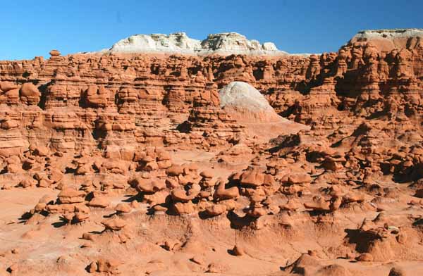
After leaving Capitol Reef, we drove to Goblin Valley.  Situated between Capitol Reef and Canyonlands, Goblin Valley is north of Hanksville, Utah.  We turned north at Hanksville, and drove across flat land and fields toward the state park.  This valley of eroded sandstone formations is small and contained, meaning you can roam freely without being afraid of getting lost.

Sandstone formations in Goblin Valley

The variety of features stimulates the imagination.  We climbed over and under hoodoos, and looked for shapes that reminded us of something.  Even though we reached this valley late in the day, and were tired from hiking around Capitol Reef National Park earlier, my kids were still having fun after an hour of scrambling around hoodoos.

A pair of ducks.

I thought this formation looked like a pair of ducks.  I also found a penguin and a dog.  This is a wonderful place to play.  If your kids are wearing bright colors, it is easy to spot them against the sandstone landscape.  You can always scramble to higher ground if you lose sight of someone.

Penguin

A man named Arthur Chaffin explored Goblin Valley extensively, and photographed it, in the 1920s.  He nicknamed the area "Mushroom Valley," and you can definitely see why.

The guys sample a mushroom in Goblin Valley.

This particular mushroom-shaped rock formation gave us an "Alice in Wonderland" moment.  We had so much fun climbing around here.  There is a surprising variety in the rock formations.  Rock has eroded at different rates, sometimes leaving small, scattered hoodoos, and other times leaving tall formations that tower above you.

Wandering in Goblin Valley

Goblin Valley State Park is open year-round.  However, during the winter season (November through February), the Visitor's Center may be closed during lunch hours or on an occasional day when the park is short staffed.  We spent a couple hours here playing in the main valley of goblins before heading to Green River for dinner. Camping is available in the park, and there are hiking trails as well.  This place was definitely a family favorite, and I expect we will plan some return visits to this park!


Friday, October 28, 2011

Hiking the Little Cottonwood Trail

Ruins of a mill

Tucked away in the trees beside Little Cottonwood Creek are the ruins of an old mill.  It is a pretty easy hike to reach the spot where you can view the mill.  The ruins are actually across the creek, which was still running fairly high when I went on this hike.  The mill-side of the creek also has a high wall rising from the creek bank to the mill, making access difficult.  I would NOT recommend crossing the creek and attempting to get to the mill at this point of the trail.

Little Cottonwood Creek

The trail leaves from a parking area on the south side of the road up Little Cottonwood Canyon.  If you cross the street, you will see the trailhead for Lisa Falls.  It is easy to do both hikes in one outing.  The trail to the mill ruins dips down from the road.  When the trail forks, turn left and head east up the trail to the mill ruins.

View from the trail.


This hike is fairly shady.  The trail is used by mountain bikers, so be aware of that as you hike.  You will have glimpses of the creek as you hike as well.

Wall on the mill-side bank of the creek.

When you reach the mill viewing area, you can perch on the wall and have a snack or some water.  If you continue on a little further up the trail, you will discover the remains of an old car.  It is an odd place to find a vehicle, and I wonder what story this pile of metal would tell!


Old car parts


View from the trail.

This is a pretty hike and is only 1.6 miles round-trip.  It is an out-and-back hike, and the parking area is located about 2.7 miles up Little Cottonwood Canyon. You may park on either side of the road.  The trail is wide and easy to follow, and is not very steep.  In fact, the guide book I looked in gave this hike a net elevation loss of 170 feet!  This is a great hike to do when you are short on time.


Mill ruins in Little Cottonwood Canyon


Tuesday, October 11, 2011

Hiking the Timpanogos Cave Trail

American Fork Canyon

Timpanogos Cave is located up American Fork canyon.  From I-15, take Exit 287 and follow it traveling east  on UT-92 to the cave visitor's center.  You have to hike about a mile and a half up an improved trail to reach the cave entrance.  Reservations are strongly recommended.  We purchased our tickets in advance and were glad, as cave tours can sell out quickly on weekends.

Timpanogos Cave trail

The hike is a pretty steady climb, made easier with a series of switchbacks.  You will climb over 1000 feet in elevation before reaching the cave's entrance.  After listening to a safety talk by a ranger, you are allowed to begin your hike to the cave.  Tour tickets allow you between an hour and an hour and a half to make the hike.  We had no trouble making our time slot.

Tunnel on the trail

This is a really beautiful hike and has great views of American Fork canyon.  There are a couple of short "tunnels" on the trail, as well as pretty flowers and interesting rock formations.

The trail goes right through the rock.

There are benches along the way if you need to stop and rest, and there are also shady areas on the trail.  Water is only available at the visitor's center, so carry some with you on the hike.

Take a minute to enjoy the scenery!

Flowers along the way.

At the top of the trail, there is a restroom if you need it.  Also, if you are carrying a large pack, or baby/toddler backpack, there is an area to leave your items while you tour the cave.  Only small packs are allowed inside.  Timpanogos Cave is much smaller and narrower than Minnetonka Cave, for example, and you will have to squeeze through some narrow spots inside, so carry as little as possible.

Restroom at the top of the trail.

Backpack parking

If you arrive before your tour time, you will have to wait a few minutes at the top of the trail.  There are shady benches to rest on.  There are also interpretive signs pointing out fossils in the rock.

Fossils near Timpanogos Cave

Fossils from an ancient sea.

Even if you cannot get cave entrance tickets, this is a really beautiful hike.  Parking is available at  the visitor's center, with overflow parking across the street, and another small parking area a bit further up the canyon.  There is also a nice picnic area in the canyon before you reach the visitor's center.

Next up:  inside Timpanogos Cave!


Wednesday, September 28, 2011

Hiking to Lisa Falls

Lisa Falls - Little Cottonwood Canyon

This little waterfall is only about a tenth of a mile off the road in Little Cottonwood Canyon.  It is secluded enough, and far enough off the highway that it is a welcome escape.  The last part of the trail is a scramble over rocks in the stream bed.  It may be wet in the spring, but is dry in late summer and fall.  The water flows down smooth granite, giving off a cool and refreshing spray.

Lisa Falls

To the right of the falls, climbing anchors are embedded in the granite walls.  Obviously, this is used as a climbing site, but no one else has been there the times I have visited the falls.  There are large boulders and flat areas that beg to be a picnic site.  One of these times I am going to remember to bring lunch!


Lisa Falls is definitely worth a look and the short trail makes it accessible to many types of hikers.  It can get steep in places, and the rocks can be slippery, but it is a short walk.

The falls are a great destination for all ages.

The trailhead is about 2.7 miles up Little Cottonwood Canyon (Utah hwy. 210).  There is parking on either side of the road.  The north side is the trail for Lisa Falls, while the south side is the Little Cottonwood Trail. There are no facilities here. 

Monday, September 26, 2011

Hiking the Nebo Bench Trail

Mt. Nebo, Utah

The Nebo Bench Trail is located on the Nebo Loop Scenic Byway in Utah.  It is quite a lengthy trail, and we opted to just do part of the trail as an out-and-back hike.  We visited in mid-August.  The scenery on this trail is stunning, but the trail was not well-maintained.  That may be due to the high snowpack this year, which caused many high-country areas to remain closed until late July.  I wondered if perhaps people who normally clear trails had not been able to this year.

Sign marking the trail.

My guide for this hike was Best Hikes With Children in Utah, which suggested a turnaround point about 3.4 miles in.  We opted to turn back earlier.  This hike begins at an altitude of about 9300 feet.  I felt the altitude! However, the trail has gradual ups and downs, and relatively flat sections in the early going, so it wasn't too bad.

Early in the hike, the trail crosses beautiful meadows.

One unusual thing about hiking this area was running across cows.  We didn't see anything but the piles they had left behind hiking in, but on the way out, we encountered bovines.

Beginning of the trail

ONE big tree had been cleared at the beginning of the trail, but there were places on this hike where we had to duck under branches, climb over trees, or sometimes follow a faint trail around the blockage and then return to the main trail.

Where's the trail?

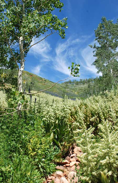
Despite the small setbacks, this was a pretty hike.  Sometimes the trail goes through groves of aspen, and other times it crosses meadows of wildflowers. 

Aspen trees on the Nebo Bench Trail

Wildflowers add some color to the slopes.

We had to hike in a couple miles to get views of Mt. Nebo, but it was well worth it.  We turned back before the trail turned steadily up hill.

The trail crosses a dry stream bed.

Mt. Nebo from the Nebo Bench Trail

I love wildflowers, and there were several varieties in bloom.  We spotted bluebells, lupine, columbine, forget-me-nots, and more.

Bluebells

Columbine

Forget-me-not

Flowers on the Nebo Bench Trail

Bumblebee checks out the lupine.

If you get a chance to drive the Nebo Loop Scenic Byway between Payson and Nephi, Utah, stop and see some of the sights.  We thoroughly enjoyed doing a small part of the Nebo Bench Trail, and also enjoyed our visit to Devil's Kitchen.

IF YOU GO:  Take I-15 to Nephi, Utah, then take exit 225 onto UT-132 (heading east).  After about 6 miles, turn left on the Nebo Loop and follow it for about 12 miles to the trailhead.  There are vault toilets at the trailhead, but no water.  There is ample parking in the lot.


Wednesday, September 14, 2011

Hiking Utah - Book Recommendations

Aspen in Big Cottonwood Canyon

I am fortunate enough to live minutes away from wonderful hiking areas in Utah.  Utah is a scenic treasure trove, and it would be a shame to live here and never venture outdoors!

I am a very casual, recreational hiker.  I have a couple of great guidebooks that have helped me explore a variety of wonderful trails, so if you want a book to help you enjoy some beautiful scenery at a comfortable pace, here are my recommendations.

The first book is called "Best Hikes with Children in Utah," and is a very detailed, wonderful guide featuring hikes from all over the state.  Written by Maureen Keilty, this book was first published in 1993, and was revised in 1997.  I have taken my children on several of the hikes in this book over the years, and have found that if the hike is rated "easy" to "moderate" for kids, it is a very comfortable hike for me as well!  This book is divided into regions, and includes 75 different hikes. I am still working my way through them.  It only includes a small sampling of the great hikes around Salt Lake City, which is why I recommend having another book along with it.

Donut Falls

The second book I recommend is "Best Easy Day Hikes Salt Lake City."  This Falcon Guide by Brian Brinkerhoff is a great reference for convenient, short outings.  There are 24 hikes in this guide, and I have done 13 of them, some of them more than once.  The driving directions are wonderfully accurate, and the hikes are rated by difficulty so you can work your way up from the easiest if you would like.

Alpine meadow

These books have offerings appropriate for all ages and abilities.  I encourage you to take your kids hiking.  Even a toddler can enjoy the sights from a backpack carrier, although my son used to fall asleep in his. Each of my children has surpassed my levels of hiking and camping (one has been to the Himalayas, and one has climbed King's Peak in Utah)  Introducing them to this activity while they were young opened many doors for them, and I hope they will continue to enjoy all that the outdoors has to offer.

So, get a guidebook, and get out hiking!  There are still several weeks of wildflowers and fall colors left in the hiking season. Take advantage of the cooling temperatures and soak up some scenery before the snow flies.  See you on the trail!

Lupine in Bloom - Nebo Bench Trail