Showing posts with label day trips. Show all posts

Thursday, January 5, 2012

Visiting Capitol Reef - Panorama Point

We stopped on the drive into Capitol Reef to get this photograph.

The town of Torrey, Utah is near the entrance of Capitol Reef, and that is where we spent the night after our day visiting three of Utah's state parks (Kodachrome Basin, Escalante Petrified Forest State Park, and Anasazi State Park).  After breakfast at our motel, we drove into Capitol Reef National Park to spend part of the day.  I have driven through Capitol Reef before, but had never really explored the park.  What a wonderful surprise!  I loved the scenery, and there are many hiking opportunities.  I had planned for us to spend half the day at the park, have lunch, and then continue on to our next destination.  However, we became so enamored with this place, we lingered late into the day.

Scenery driving into Capitol Reef

Driving east into the park on Hwy. 24, we passed wonderful rock formations with beautiful colors.  The morning light made everything vibrant, and we were excited to start our day.  We stopped at Panorama Point to see the view, and ended up spending time clambering over the rocks and wandering out to the end of the narrow point.

Out on Panorama Point

My kids had a great time scampering over these rock formations, and are fortunately at an age where I wasn't too concerned they would get too close to the edge.  We ended up spending quite a bit of time here, and as the sun rose, the brisk breeze calmed, and we knew we were in for a beautiful day.

The guys at Panorama Point

From Highway 24, you will see the signs for the turn-off to Panorama Point.  It is a short drive to the parking area, and an even shorter walk to the viewing area.  Many visitors choose to return to their car and Hwy. 24 from the viewing area, but if you are more adventurous, wander out onto the rocks and spend a little time here.  The views are spectacular, and it is a very satisfying place to start the day.

View from Panorama Point - Capitol Reef National Park

As we left Panorama Point, we noticed a gravel road leading to the Goosenecks.  It was a short distance, and the road was in good condition, so we decided to take this detour before returning to Highway 24.  Sulphur Creek has carved deep into the canyon here, and while the site is smaller and less impressive than Dead Horse Point, we still enjoyed stopping and taking in the view from the overlook.  

Looking down into the Goosenecks of Sulphur Creek 

After leaving the Goosenecks, we returned to Highway 24 and continued on to the Visitor's Center. The day we visited Capitol Reef was a free entrance day at the park (can't complain about that!). We got advice on hikes from the rangers at the park, and then headed out for our first hike of the day. Stay tuned for more of our adventures in Capitol Reef!


Friday, October 21, 2011

Visiting Grosvenor Arch in Utah

Grosvenor Arch


Grosvenor Arch is in the Grand Staircase Escalante National Monument.  As you drive from Tropic, Utah toward Kodachrome Basin, you will see the turn off for the dirt road leading to this arch.  This is a little bit off the beaten path, but was driveable in a minivan. 

Dirt road leading to the arch

Most of the way, the dirt road is in pretty good shape.  However, there are sections that are a little more treacherous.  This road would be very difficult in a rainstorm. Even with 4WD, some sections would be impassable during heavy rainfall.

Another view of the dirt road

We were grateful there wasn't a cloud in the sky the day we visited (Sept. 23, 2011).  As you climb on the dirt road, you will pass a view area.  Stop a minute and just soak up the scenery.

Ugly Bot on the road to Grosvenor Arch

View Area

There is a parking area at Grosvenor Arch.  Ironically, although you have to drive on a dirt road to get to the arch, there is a sidewalk from the parking area to the arch itself.  No kidding!  Cement sidewalk all the way.

Grosvenor Arch

This rock formation is very majestic.  Tall and powerful, it stands out against the flat sagebrush.  We were glad to catch it in morning light.


Under the arch

The sidewalk ends before you actually reach the arch.  When we visited, there were some German tourists, but otherwise we had the place to ourselves.  It was very peaceful.

The arch up close!

We saw a couple of picnic tables, but no shade.  There is also a vault toilet.  Otherwise, there are no facilities at this location.

The sagebrush was in bloom.

This was a great start to our day trip, and we were definitely glad we made the effort to see this.  Next stop:  Kodachrome Basin State Park.  

IF YOU GO:  Plan on 10 - 11 miles on the dirt road.  It took us a little more than an hour to reach Grosvenor Arch from Tropic, Utah.  Take food and water.  Leaving Tropic, drive east on Highway 12, then turn off near Cannonville on the Cottonwood Canyon Road.  Watch for signs for the turn off to Grosvenor Arch. There is a parking area and vault toilet at Grosvenor Arch.  Also, there are a couple of picnic tables, but no other facilities. There are no fees to drive to the arch.


Monday, September 12, 2011

Elusive Ghost Towns: Mammoth and Silver City

Old mining building in Mammoth, Utah

Utah has its share of ghost towns, so visiting some of them seemed like a good summertime activity, and also an opportunity to take some interesting photographs.  However, finding ghost towns is a bit like finding ghosts themselves.  Unlike movie or tv versions of ghost towns, many local ones contain live residents (and I believe in respecting their privacy and property), or, instead of deserted main streets full of cool old buildings, there is often very little left at all. 

Mining companies in both Mammoth and Silver City have opened operations, and we found the parts of these towns where the interesting old buildings reside are blocked off by gates and large "No Trespassing" and "Danger" signs.  I was therefore limited in what I could see and experience in these two places, but here is a photographic taste of what IS available.

Abandoned house in Mammoth

Old building in Mammoth, Utah

Mammoth is not far from Eureka, Utah (about 3 miles south).  Part of the Tintic Mining District, Mammoth grew in the 1870s during a gold and silver mining boom.  Today, it is definitely a quiet place.  We drove a looping road and had distant views of the mining area, and were also able to see some old buildings. There are no services here.  

Climb the "Stairs to Nowhere" in Mammoth

These stairs and some foundations are all that is left of whatever building once stood here.  We also saw wooden stadium bleachers from an old baseball field.  We left Mammoth with a few photos, and headed for Silver City, where we hoped to have better luck.

Flowers in Mammoth

Silver City - Tailings Pile

We found even less in Silver City.  There were tailings piles everywhere, and some were fenced off.  It looks like some entity has tried to close off many areas out of safety concerns.  We did see some people camping and there were ATV trails around, but as you follow the road toward the old mining area, you will encounter a sign that the Dragon Mine is in operation.  This area is gated off and is posted "No Trespassing."  I did not go beyond that point.

Big hole outside Silver City

Person by the big hole, for scale.

It was fun to stop for a few minutes and look at the evidence of old mining ventures, like this large hole in the ground.  However, there isn't much else to do in this area.  I was grateful we had other things planned on this day trip!


Wednesday, August 10, 2011

Visiting the Spiral Jetty at the Great Salt Lake

Spiral Jetty at the Great Salt Lake

Of course, during all the drought years, I never made it up to see the Spiral Jetty while it was out of the water.  When we visited the jetty this year, it was not only under water, but the time of day made it hard to see.  There was a lot of glare on the water, and I suspect it may be more visible at other times of day.  The Spiral Jetty was constructed by Robert Smithson in 1970.  It has always been a bit controversial (was he messing up nature?  was it a dumb idea?  was it "art"?), so I was curious to see it.

Lichen on an igneous rock.

The jetty, from shore, was scarcely visible in the glare, so we hiked up the hillside for a better look.  There is a faint trail heading up...and up.  It isn't a bad climb, though, and one of the attractions of this point on the north end of the Great Salt Lake is the fact that it is quite remote.  The breeze and a few birds and insects were all we could hear.  The igneous rock makes this look like an alien landscape, and there is beauty in the starkness.

Interesting rock shapes overlooking Great Salt Lake


Rabbit at the top of the hill

My husband and son followed and photographed this rabbit after climbing up for a better view of the jetty.  One of the fun things about getting out is seeing different wildlife!  This was a beautiful spot to end our day trip.  It was hot, though, and a couple of us wanted to get our hair off our necks, but hadn't brought any hair elastics.  If you have a well-packed picnic bag (I'll talk about that in a future post), however, anything is possible.  Twisty-ties for plastic bags did the trick!

A little ingenuity...twisty-ties for pony tails!

So, I think Robert Smithson didn't do anything to damage nature here.  This is a remote, barren place, and the Great Salt Lake is large enough to absorb this small intrusion without much consequence.  Of course, you couldn't have dozens of people wanting to create art in the lake, so maybe this is a case of the advantage going to the first one.  I DO think the Spiral Jetty is a piece of art.  Great thought and effort went into its creation, and rather than distracting from the landscape, it fits in.  Smithson was wise to choose such a remote place, where only those who really want to see it would bother to come.  It is worth a look, and I look forward to returning in a dry year so I can see the jetty out of the water as well.

A barely visible Spiral Jetty

Spiral Jetty as seen from the hillside.

Make sure you take in the scenery if you go.  After all, you don't "stumble" upon this location, so take the time to have a good look around, and appreciate the size of this unique lake that spans several counties in Utah. 

View of the Great Salt Lake

Ugly-Bot at the Spiral Jetty

NOT the Spiral Jetty!

This jetty is a remnant of an old oil-drilling operation.  It is NOT the Spiral Jetty.  While we were in the parking lot, we saw a vehicle from Arizona stop at this jetty. It's occupants looked at it and photographed it then pulled in the parking lot by the actual Spiral Jetty, turned around, and left without seeing the real thing! So, if you drive all the way out here, please make sure you see the real thing.

Leaving the Spiral Jetty

On the trip back up the dirt road from the jetty, we saw beautiful scenery, and a little unexpected surprise!  Perhaps we are not alone....

Alien road signs?

If you travel to the Spiral Jetty, take Highway 83 west from Brigham City.  After you pass the Golden Spike National Historic Site, you will see a turn-off heading south on a dirt road.  This dirt road will take you to the Spiral Jetty (there is a sign).  The staff at the Golden Spike visitor's center are also very helpful with information on the jetty.  This is a pretty good dirt road, although the last 2 miles are more rutted and rough.  We traveled in a mini-van, and it is passable by passenger car.  Park at the circular "parking lot" at the end of the road, and you are at the Spiral Jetty!
As I am sure you might guess, there are NO services here.


Friday, August 5, 2011

Golden Spike National Historic Site

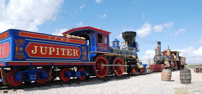
Replica Trains at the Historic Site

I decided it was finally time to venture out and see the Golden Spike National Historic Site.  After all, it does commemorate a significant event in Utah and American history, and I had never been there before.  On May 10, 1869, the Central Pacific's train, Jupiter, and the Union Pacific's train, No. 119, stopped while the track was joined by a golden spike.  This connected the east and west coasts by rail. You can see the two replica trains from the road. The visitor's center is about 32 miles west of Brigham City, Utah. There are restrooms available. Admission on the day we went was $7 for a passenger vehicle.  

Replica of the Golden Spike

The golden spike driven to connect the railroad across America is not on display at the site.  Central Pacific's president was Leland Stanford, and the original spike rests at a museum at the university named for him in Palo Alto, California.  However, you can view this replica here.  The replica's claim to fame is that it went into space on board the space shuttle Atlantis in 1990, so that does enhance its status!

Union Pacific No. 119 - replica train

The No. 119 is one of two replica trains on site.  It is a coal-burning steam engine.  The other train, the Jupiter, is wood-burning.  When its coal tender was full, a train like this could go 150 miles before re-fueling with coal.  However, the train had to stop every 15 to 30 miles to refill its water tank for the steam.  This particular train holds 2,000 gallons of water.  The replica trains have been painted with period-accurate detail.  The No. 119 features some landscape paintings on its corners.

Detail of the No. 119 train

The Jupiter

You can walk around the trains, and climb up on a viewing stand to see inside them.  The trains are moved a couple of times a day, and if you happen to be there when they are getting the trains out, or putting them in the barn for the night.  It doesn't take long, and is interesting to watch.  There are rough wooden benches to sit on, and park employees give information about the trains while you watch them move.  (You can wander during the presentation and take pictures...just stay back from the tracks!) We saw the No. 119 drive back to the barn for the evening (about 4pm).

View of the Jupiter and the No. 119

No. 119 on the move!

We watched the train stop, switch tracks, come forward, and then reverse to the barn.  The fireman manually switches the track.  Visitors get to hear the different train whistles used to signal things like "reversing" or "coming through but not stopping."  It is quite a show to watch these steam engines on the move, and we enjoyed it.

Scenery from the Golden Spike National Historic Site

This area of Utah can be very hot and dry in the summer.  Water is available at the visitor's center, but traveling in this relatively remote area, it is always good to bring your own.  The visitor's center has a book section and gift shop, and sells some snacks and drinks.  You can watch an audio-visual presentation, take a hike, or drive two different auto-tours.  There are plaques commemorating some of the diverse groups who worked laying track through miles of harsh conditions, including many Chinese immigrants.  Be aware if you visit that the replica trains are only operational during the summer months.

This was a nice stop on our day trip, and I am happy to now say that I have been to the Golden Spike National Historic Site!


Tuesday, August 2, 2011

Minnetonka Cave

The cave entrance - enlarged so you don't have to crawl.

Where can you find dwarves, ghosts, Whos in Who-ville, and King Kong all under one roof?  The Minnetonka Cave! It was with no small amount of excitement that I actually left the state of Utah this week, and traveled to Idaho to see the Minnetonka Cave.  This cave is not far from Bear Lake, and is up a beautiful canyon.  Our drive from Salt Lake City was more like a swim, as we had heavy rain most of the way.  If you take this day trip, plan on about 3 hours to reach the cave from Salt Lake City.

Clouds over Bear Lake

Minnetonka means "falling water."  This is a really beautiful cave.  Compared to Timpanogos Cave in Utah, this cave is very spacious.  The Ballroom in the cave measures about 300 feet in length, and almost 90 feet from its lowest point to the top.

The Three Sisters

There are 444 steps inside this cave.  It is an out & back, so you will retrace those same 444 stairs on your way out.  However, the stairs are broken up with straight stretches, and you go both up and down before reaching the last chamber of the cave.  If you don't have difficulty on stairs, this cave is completely manageable.  As a living cave, it is damp, and slick in areas, but there are handrails.  Bring a jacket (and maybe gloves...those metal handrails are cold)!  Cave temperatures hover at 40 degrees Fahrenheit year round.  Much of the cave improvements were done as a WPA project during the Depression. 

Columns in the cave

Stalagmites grow from the bottom, and stalactites "hold on tight" to the top of the cave.  Columns connect top and bottom.  We saw a beautiful ceiling of soda straws, where the water goes through the straw and drips out the end.
A feature in Minnetonka Cave

The rooms in the cave have names like "Dwarf Kingdom" where you can see the Three Sisters, all seven dwarves, and Casper the friendly ghost.  Following the Dwarf Kingdom are rooms like the Ballroom and Wedding Room.  The Wedding Room features a ring, a bride and groom, and organ pipes.

Kermit's Castle is illuminated by a green light.

"Coins" glisten in the Treasure Room

After descending a long metal staircase, you can peek into the red glow of the Devil's Office.  Of course, on your way out of the cave, you will have to climb this "Stairway to Heaven."

Stairway to Heaven in Minnetonka Cave

This was a wonderful day trip, and I loved this cave.  The cave is open from 10am to 5:30pm during the summer months, with tours beginning every 1/2 hour.  Up to 30 people can be on a tour.  We were fortunate enough to make the 10:30am tour, and only had 10 people in our group.  The groups coming in after us had over 20 people, and I am glad we had a small, more intimate tour.  The tour lasts about 90 minutes.  On our way back, our guide asked us if we wanted to walk a flat stretch with the lights off, only holding the hand rail for guidance.  Everyone agreed, and we walked a short distance in complete darkness.  That is an amazing experience!  It is hard to comprehend the blackness of cave interiors until those lights go out.

"Melting" rock inside the cave.

It is a bit tricky photographing inside a cave, but we were lucky with a few of these photos!  Minnetonka contains fossils from about 350 million years ago.  It has beautiful features, and our tour guide was great.  Reservations are NOT taken in advance, so it is possible to get to the cave and have to wait a few hours for your tour.  Your best bet is to arrive early!  There are restrooms at the cave entrance, and a few tables if you have a picnic lunch with you.
View of the forest from Minnetonka Cave

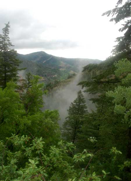
The cave is a short walk from the ticket booth.  On your way, you overlook a dense forest.  There was mist rising in the trees on the day we visited.

Lichen on the rocks

If you go, be wary of the Mapquest directions!  Our directions had us turn off of Highway 89 prematurely, and left us on narrow, winding dirt roads in a small neighborhood.  Residents had posted handwritten signs to direct traffic toward the cave.  Our directions told us to turn onto 200 N. from Highway 89.  DO NOT DO THIS.  Stay on Hwy. 89 (heading north) and pass St. Charles Creek, and The Bear Cave drive in, and then you will see a large, brown sign directing you to turn left for the Minnetonka Cave.  Make this turn onto Minnetonka Cave Road and follow it ten miles to the cave parking lot!

Several places advertise the famous Bear Lake Raspberry milkshakes

On our way back to Utah from Minnetonka cave, we stopped to sample a raspberry milkshake.  This particular drive in advertised that theirs were the tastiest, but they had plenty of competition.

A great way to end the day!