Saturday, October 8, 2011

Visiting the Great Basin Museum

The Great Basin Museum is located in Delta, Utah.  It contains an eclectic mix of local nostalgia, geology, and national history.

Trilobites in the Great Basin Museum collection

Delta is near many world-class rock, mineral, and fossil collecting sites.  Trilobite beds and Topaz mountain are just a few miles away.  The museum houses samples of trilobites, ancient plant fossils, and an interesting grouping of glowing rocks.  One of the museum docents switched off the lights and showed us the neon colors that appeared in different spectrum lighting.  This is a great stop for the rock hound in your family.

Statehood Flag

This flag was created to display on Utah's Statehood Day - January 4, 1896.  It has 45 stars, as Utah was the 45th state.  At the museum, it hangs near a replica doctor's office featuring items from Dr. Bird's practice.  He was a long time Delta resident and physician.

X-ray machine

After you pass the exhibits about local mining and beryllium, you round the corner and find this oddity.  This x-ray machine was used to see if your shoes fit.  Really!  A child would try on a pair of shoes, and then stand with his/her feet in the machine.  The machine would x-ray, allowing the store clerk (and parent) to see if the shoe really did fit the child's foot!  At some point, someone decided exposure to radiation while shoe shopping was probably not a good idea, and now the machine lives here in the Great Basin Museum.
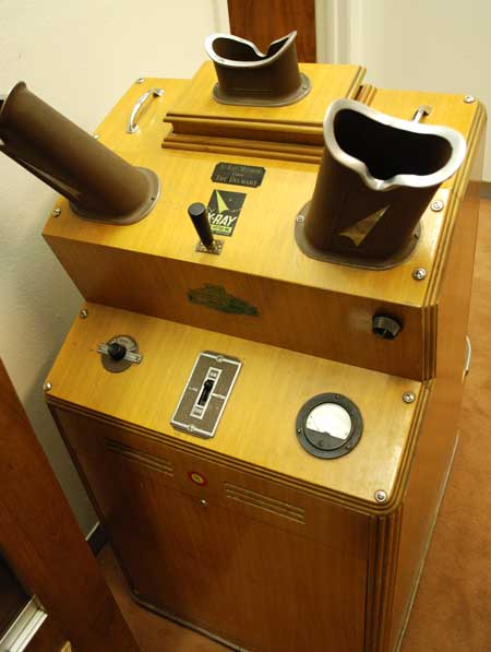
Another view of the x-ray machine


Switchboard

This switchboard was used for telephone service in town.  A 1949 phone directory is also on display, and my husband had fun locating his grandfather's phone number on it.

Typewriters

Vintage equipment such as typewriters, cash registers, and sewing machines are also on display.  You can stroll past the general store or look in an old school room while you are here as well.

General  Store display - Great Basin Museum

Seeing so many everyday items preserved makes one think at what point is something "museum quality" and when is it "old junk?"  This place gives a snapshot of an era, and perhaps that is what all museums do.  After all, is it really that different to look at tools found in an archeological dig, or tools your great-grandfather used?

Folk art piece

These sculptures made from old hammers were fun to look at.  This museum has a little bit of everything.  Once you are through browsing the interior, take a walk outside.  The exhibits continue behind the museum building.


Farm equipment

Outside, old pieces of farm equipment are artfully arranged.  This area of the museum also houses a barracks from the Topaz Relocation Center where 8,300 Japanese Americans lived during World War II.  

Steampunk Zen Garden?

Where's Superman?  Phone booth at the Great Basin Museum

If you are in Delta, the Great Basin Museum is located at 328 W. 100 North.  It is open Monday through Friday from 10 - 4, and on Saturdays from 1 - 4.  It is also open Memorial Day and July 4, but is closed on other major holidays and Sundays.  This is a great stop to explore a little local history, both prehistoric and recent!


Thursday, October 6, 2011

Topaz Relocation Center

The Great Basin Museum in Delta, Utah, is currently home to an exhibit about the Topaz Relocation Center (internment camp) that existed in Utah during World War II.  It was built in 1942, and at its peak, housed over 8,300 Japanese-Americans.  Most of the people at Topaz came from the San Francisco area of California.

Barracks from the Topaz site

Residents were housed in small barracks like this one.  They were not well-built, and were cold in winter and hot in the summer.  Temperatures ranged from highs of 106 degrees in summer, to lows of 30 degrees in winter.  The Japanese-American residents built furniture, and organized a society here with as much normalcy as they could.  They formed sports teams, musical groups, schools, and Girl Scout and Boy Scout troops.  Basically, this unfairly displaced group of people made the best of a horrible situation.

Inside the barracks

The barracks were sparsely furnished.  The only furniture issued to residents were bunks and a pot-bellied stove.  Anything else they wanted, they had to make themselves.  Piecing together scraps, internees built tables, chairs, and other things to make life more comfortable.

Antenna made by Topaz residents

The internees were not allowed much contact with the outside world. Things like radios, cameras, and even field glasses were forbidden.  However, clever and enterprising internees made this antenna to receive radio broadcasts from outside their camp.  There is a photo of the antenna mounted on the barracks wall in the museum.

Antenna on the barracks wall - photo

Sign at the museum

This sign is a profound reminder of the realities of this chapter in American history.  So many Americans were rounded up and forced to leave their homes and belongings.  Then they were asked to pledge their loyalty to America and to sign away all allegiance to the emperor of Japan.  This put many of them in a tough situation.  Recent immigrants were concerned that if America, their adopted country, failed them, they would have nowhere to go.  Others who were born and raised in America (often not even speaking Japanese) resented having to declare loyalty to a country where they were already rightfully citizens.

Drawing of the layout of Topaz

Nothing remains at the original Topaz camp site except some foundations.  After the war, buildings were sold off to local residents.  My husband's family owns one of the buildings on the family farm. Many farmers took buildings to use on their farms as tool sheds, etc.  If you want to see what the barracks were like and get a taste of life at Topaz, visit the Great Basin Museum in Delta.  A Topaz Museum is planned and will hopefully be built one day, but for now, the Great Basin Museum provides housing for these historical artifacts.

Items recovered from the Topaz site

Many items have been excavated from the Topaz camp area and are on display at the museum.  They are reminders of a people forced into harsh conditions who still tried to maintain gentility and culture in their lives.

Document at the Great Basin Museum

A great way to learn more about the plight of our fellow-citizens of Japanese heritage during World War II is to pick up a good book.  Here are some recommendations!

Hotel on the Corner of Bitter and Sweet (fiction, set in Washington)
The Magic of Ordinary Days (fiction, set in Colorado)
The Children of Topaz (non-fiction, based on a class diary)


If you go:  the Great Basin Museum is located at 328 W. 100 N. in Delta, Utah.  
Phone number:  435-864-5013
Hours:  Monday through Friday 10 -4
Saturdays, 1 - 4.  The museum is closed on most major holidays.


Wednesday, October 5, 2011

Visiting Fort Deseret and the Great Stone Face in Utah

Fort Deseret, Utah

Fort Deseret is located about 10 miles outside of Delta, Utah.  It was erected in 1865, and is the only remaining adobe fort in Utah.  Several were constructed by Mormon pioneers to give added safety and security to their settlements and livestock.  Ft. Deseret was built during the Blackhawk wars in Utah.  The army was involved in the Civil War and could not protect the settlers.

Adobe walls - Fort Deseret interior

The fort was built of thick adobe (straw and mud mixed by oxen trampling on it).  The walls are built on a lava rock foundation.  They are thick, and about 10 feet high.  There are several portholes in strategic locations so that people in the fort could shoot out if necessary.

Gun porthole in the fort wall.

This is a nice little stop just outside of Delta.  It is on the National Register of Historic Places.  There were a couple of picnic tables in clusters of shade trees outside of the fort, but otherwise there are no services here.  It is interesting to stop for a few minutes and walk around inside.  The fort is not terribly large, and I am sure the settlers were glad it was not necessary to use it very often!

Just beyond Fort Deseret is the turn off to the Great Stone Face.  This rock formation is said to look like the LDS prophet Joseph Smith.  As we turned west and headed for the Great Stone Face on a well-groomed and maintained gravel road, we saw a coyote trotting away across a field.  Just before you reach the Great Stone Face, you will see a sign marking the Great Stone Face Petroglyphs.

Great Stone Face Petroglyphs

The petroglyphs are marked by a BLM sign, and are fenced off to help discourage further damage and vandalism.  These particular petroglyphs are dated about 1000 A.D.

Petroglyphs

Petroglyphs fascinate me.  I love the stylized design, and although they may have been originally carved for some specific purpose, they seem like art to me today.  Just beyond the petroglyphs you can see the rock formation of the Great Stone Face.

Great Stone Face

This rock formation DOES look a lot like a person's profile, and it does resemble paintings of the LDS prophet Joseph Smith, so you can see why early settlers found a resemblance.

Great Stone Face close-up

To reach Fort Deseret, take Highway 257 from Delta, Utah (you will travel west, and south).  The fort is right off the road, about 2 miles beyond the town of Deseret.  Continue on the road to the turn off to the Great Stone Face.  That road is not paved, but is in really good condition.

If you are in Delta, Utah, consider driving a few miles further to visit these interesting places!


Monday, October 3, 2011

Hiking to Paul Bunyan's Woodpile

Paul Bunyan's Woodpile

Many times on the way to Delta, Utah, we have passed the sign for Paul Bunyan's woodpile.  I have often wanted to stop and check it out, but the timing was never right.  So of course, when we decided to commit and actually see the woodpile this year, the sign was gone!  Yes, we made it all the way to Delta without seeing the sign for the turn-off to the woodpile.  However, a really helpful person at the Great Basin Museum in Delta steered us in the right direction, and we were able to find the right road. 

The "woodpile" is really a geologic formation.  Formed by igneous rock, it is a remnant of volcanic activity in this area of Utah, Juab county.  These columnar joints are quite fascinating, and do look like stacked wood from the right angle!  For a more detailed description of how this unique feature may have formed, click here.  Be aware that if you decide to hike to the woodpile and see it for yourself, you will first have to drive on a  dirt road, and then hike a not-so-marked trail.  DO NOT DO THIS IN WET WEATHER!  We are guessing the sign was removed as the road and trail do not seem like they are being maintained.  Try this at your own risk.  That being said, we DID manage the road in our trusty minivan.

Sign indicating 3 miles on the dirt road

Once you locate the turn-off, however, you will see this sign indicating you are on the right road.  If you are traveling north on Highway 6 from Delta, the dirt road is about 2 miles north of the turn-off to the Little Sahara sand dunes.  It is between mile markers 125 and 126.  You will only see the back side of a stop sign on the road.  Turn east, and drive carefully on this rutted, pitted dirt road.  If you don't see the trailhead sign, you are not on the right road.

When traveling west back to the main road, you can see the stop sign.
This is the good part of the dirt road!

Trail head with woodpile in the distance.

There is a parking area at the trailhead, but absolutely no services.  Bring plenty of water.  This hike is moderate.  On the day we went, it was hot, dry, and dusty.  Go through the cattle guard "gate" to begin the trail.  We had a hard time finding the trail, at times, and often found ourselves on cow paths.  However, since you can see where you are going, you can pick your way through the winding paths and head in the right direction.

Cactus on the trail--yes, Utah is a desert!

The book I looked in said this was a one-mile hike to the woodpile.  The Utah Geological Survey site indicated that it was 1/2 mile. The book was definitely more accurate!  Definitely allow 1 to 1-1/2 hours for a round trip, especially on a hot day.

Can you see the trail?  I couldn't!


This trail is not too steep until the last part.  If you find yourself plowing through scrub oak and ducking under trees (as I did), then you have missed the spot where a tree crosses the water and leads you to the real trail and switchbacks that go up to the woodpile.  My group did not find the switchbacks until they were on top of the woodpile.  However, the one advantage to scrambling up on your own is finding a wonderful little window that is not visible from the real trail.

The woodpile as seen from the trail.

The "window" at the top.

Overall, I am really glad I saw this geologic formation.  If I ever go back, I would choose a cooler day.

Igneous rock formations at Paul Bunyan's Woodpile

IF YOU GO: from Salt Lake City, head south on I-15, and then turn west on Highway 6 toward Eureka.  Stay on Highway 6 and look for the dirt road heading east between mile marker 125 and 126.  Follow the dirt road for 3 miles to the trailhead.

We saw this deer from the dirt road.

We didn't really encounter any cows on this trail, but we did see a deer as we headed back on the dirt road to Highway 6.

Winkolina at Paul Bunyan's Woodpile

Overall, it was a good hike with good company, even if we did it during a really hot part of the day!  Utah has many unique and wonderful geologic features, and I was glad to explore this one!


Wednesday, September 28, 2011

Hiking to Lisa Falls

Lisa Falls - Little Cottonwood Canyon

This little waterfall is only about a tenth of a mile off the road in Little Cottonwood Canyon.  It is secluded enough, and far enough off the highway that it is a welcome escape.  The last part of the trail is a scramble over rocks in the stream bed.  It may be wet in the spring, but is dry in late summer and fall.  The water flows down smooth granite, giving off a cool and refreshing spray.

Lisa Falls

To the right of the falls, climbing anchors are embedded in the granite walls.  Obviously, this is used as a climbing site, but no one else has been there the times I have visited the falls.  There are large boulders and flat areas that beg to be a picnic site.  One of these times I am going to remember to bring lunch!


Lisa Falls is definitely worth a look and the short trail makes it accessible to many types of hikers.  It can get steep in places, and the rocks can be slippery, but it is a short walk.

The falls are a great destination for all ages.

The trailhead is about 2.7 miles up Little Cottonwood Canyon (Utah hwy. 210).  There is parking on either side of the road.  The north side is the trail for Lisa Falls, while the south side is the Little Cottonwood Trail. There are no facilities here.